|
Click on a picture for a more
detailed image. |
|
|
|
|
|
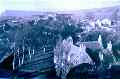
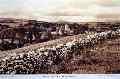
| A fine view north from
the tower towards North Hill.
|
|
 |
|
|
|
| Another good view
westwards across the Rectory gardens.
|
|
 |
|
|
|
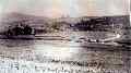
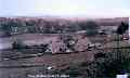
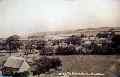
| This shot, C. 1900, shows
the two-part nature of the village, owing to the disecting,
floodable River Bride (see 178). The core of the village lies around
the church, here dominated by the former engine house of Roberts'
Flax Mill north of the river. South-over-the-Bride we have only two
old roads - Southover and Bridge Street. Mostly centre and right of
this photograph.
|
|
 |
|
|
|
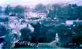
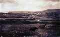
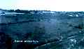
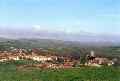
| General view of village
from hill above Southover
|
|
 |
|
|
|
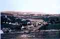
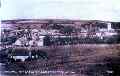
| General view of Burton
Bradstock from clifftop |
|
 |
|
|
|
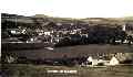
| General view of village
C. 1950 |
|
 |
|
|
|
| Southover Cottages,
mostly thatched, lie for the most part on the south side of the road
facing north, as does this view. |
|
 |
|
|
|
| Looking back towards the
village from North Hill, you can see there are no houses yet in
Beach Road.
|
|
 |
|
|
|
| Looking across to Barr
Lane from Southover
|
|
 |
|
|
|
|
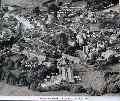
Aerial view of Burton Bradstock 1958
|
|
 |
|
|
|
| View from field above
Cheney's Garage towards North Hill
|
|
 |
|
|
|
| Just after World War II, the
Pitt-Rivers estate gave this meadow by the bridge to the village for
use as a playing field in perpetuity. Goal post marks the spot!
|
|
 |
|
|
|
| General view of Burton Bradstock as
you might see it today |
|
 |